Posts

Showing posts from July, 2023

Mission Chandrayan 2

Image
  India's second lunar exploration mission, Chandrayaan-2, was launched by the Indian Space Research Organisation (ISRO) on July 22, 2019. The mission's goal was to investigate the south polar region of the moon and advance our knowledge of its surface, geology, and potential presence of water . Chandrayaan-2 was made up primarily of three parts:- Orbiter : - The orbiter stayed in lunar orbit and carried out ongoing research of the lunar surface, its makeup, and the exosphere, a thin layer of gas that surrounds the moon. The Pragyan rover- would be deployed by the Vikram lander after a soft landing on the lunar surface close to the south pole Vikram Lander: The Vikram lander was designed to make a soft landing on the lunar surface near the south pole and deploy the Pragyan rover. The Chandrayaan 2 mission Indian Space Research Organisation (ISRO) is a space agency. Date of Launch: July 22, 2019 Geosynchronous Satellite Launch Vehicle Mark III - Mission 1 (GSLV Mk III-M1) Obje

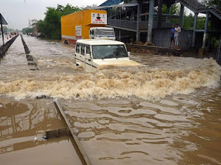
Flood and landslide in Northern India

Image
 Flooding and landslides in Northern India can be caused by a combination of factors including:  1 Heavy rainfall -Intense and protracted rainfall can cause the soil to become saturated, resulting in landslides and flooding as rivers and other water bodies overrun their banks. 2 Monsoon season -In India, the monsoon season, which normally lasts from June to September, brings a lot of rain to the area. Flooding and landslides can be caused by the excessive precipitation, especially in hilly and mountainous regions with steep slopes. 3 Topography -Landslides can occur in Northern India because of its mountainous topography, especially when there is considerable rainfall on steep slopes   4 Deforestation and soil erosion -The ground might become more susceptible to landslides as a result of soil erosion brought on by deforestation and poor land management techniques. For the purpose of absorbing rainfall and stabilising slopes, trees and other vegetation are essential.  5 Rapid urbanis

Bermuda triangle

Image
 The Devil's Triangle, often known as the Bermuda Triangle, is a location in the western North Atlantic Ocean where it is rumoured that several ships and aeroplanes have mysteriously vanished. Miami, Bermuda, and Puerto Rico form the general perimeter of the triangle. The numerous mysterious disappearances that took place within the limits of the Bermuda Triangle led to its renown. These occurrences have frequently been sensationalised by popular culture and the media and linked to supernatural or alien activity. It's crucial to remember, though, that many of the disappearances can be attributed to natural factors, like as storms, mistakes made by humans, and the size of the oceans. In the region, strange events have been reported since the early 19th century. The loss of the USS Cyclops, a cargo ship for the American Navy, with its 309-person crew in 1918 is one such instance. Although the Bermuda Triangle is still a topic of discussion and conjecture, scientific research has

Why GMT passes through London

Image
 I notice something every time I look at it.that kind of irks me.that something is this ,this zero.this zero which is not just one number,but it's actually a corresponding line that look like this The Earth is divided into lines.sometimes they're curved like they are on my map,and whether or not they're curved or straight .but just know that the earth is divided up into lines, latitude and longitude lines. Ones that go up and down and ones that go from side to side.all of these lines in the grid have a number associated with them.so for the up and down lines, there's zero point .and then anywhere to the right of that or east of that starts to go up from zero to 180 with a little E next to it for east of the zero line,and then everything to the left or west of it has the same thing zero to 180 with a W for westOkay that centre point is the zero point from which all east and west things are measured.the same thing for these side to side lines. If you go up from here, you&

The history of mapping Antarctica

Image
 Map so details so precise, an impossibility made manifest by the super humans in the future. One of their fellow explorers, earnest shakleton drew this place on back of menu once . Meaning of a Sunday crossing this whole continent, in the huge price to try. This is the place that has lured explore from all over, killing many of them. That's because the bottom of the Earth is a place that humans really shouldn't go. Our species were avail to move and settle across the whole globe from desolate eyes desert to impossible for away icelands some how we just showed up we settled. But even after we had reach every corner of the globe thousands of years ago there was a still a land mass that no human head ever leave there laid their eyes on, but something has this exist down where they thought, something to balance out all of the land in the earth with land  in the south . So explore and map makers continue to search and on these map the true that imaginary ideas ajain continents some